What Do Surveyors Do in WA? | Perth Surveying

What Do Quantity Surveyors Do in WA? A Land Survey Guide
Many WA property owners search for a quantity surveyor when they are planning to build, renovate, subdivide, or develop land. But if the question is about boundaries, site levels, building position, or subdivision requirements, the first professional they usually need is a land surveyor.
A quantity surveyor helps with project costs. A land surveyor helps you understand the land itself: the boundaries, levels, site features, building position, and subdivision requirements that shape what can be designed, approved, and built.
That difference can save time, money, and frustration. The right survey at the right time can prevent design errors, approval delays, boundary problems, and costly construction mistakes.
This guide explains what surveyors do in WA, when to book one, and how the right survey can help property owners, builders, and developers avoid delays before a project moves too far ahead. It also explains when a quantity surveyor may be useful, and when Perth Surveying is the right place to start.
What Does a Surveyor Actually Do?
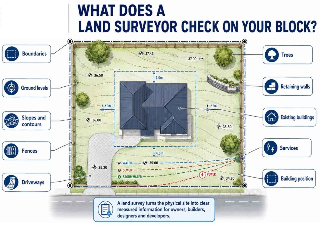
A land surveyor measures and maps land so owners, builders, designers, engineers, and developers can make accurate decisions about a site.
Before a builder can build, an architect can design, or a developer can subdivide, someone needs to know the facts of the site. Where are the boundaries? What are the levels? Where are the existing buildings, fences, trees, services, retaining walls, and slopes? What can be built, and where should it go?
That is the role of a land surveyor: turning the physical site into clear, measured information that the rest of the project can rely on.
A land survey provides accurate site information that helps prevent guesswork. This information is used by property owners, builders, architects, engineers, councils, and developers.
A land surveyor can help:
- Confirm where the property starts and ends: Useful before building near a fence, replacing a retaining wall, resolving a boundary concern, or planning a subdivision.
- Map the shape of the block, not just the size of it: A survey records levels, slopes, walls, driveways, trees, fences, buildings, and other site features that affect design and construction.
- Give architects and designers reliable site data before plans are drawn: Without a proper feature and contour survey, design work can be based on assumptions that may create delays later.
- Show builders exactly where the new work belongs: For a new home, extension, garage, pool, or retaining wall, a setout helps place the work in the correct position before construction starts.
- Help uncover issues before they become expensive: A survey can reveal boundary complications, level changes, access issues, service locations, or site constraints early in the project.
- Supports subdivision and development applications: Surveyors prepare the land information needed to divide a block, create new lots, and move the subdivision process forward.
- Creates one clear reference point for everyone involved: Owners, builders, architects, engineers, planners, and councils can all work from the same measured information instead of relying on guesswork.
This is different from the work of a quantity surveyor. A quantity surveyor usually deals with construction costs, budgets, and financial estimates. A land surveyor deals with the land itself.
So, if you want to know what a project may cost, you may need a quantity surveyor. But if you need to know your boundaries, site levels, building position, or subdivision requirements, you need a land surveyor.
A good survey gives a project a clear starting point. For builders and developers, that means fewer unknowns before work is scheduled on site. It reduces risk, helps avoid delays, and gives everyone involved the same reliable information to work from.

Land Surveyor vs Quantity Surveyor: What Is the Difference?
The word surveyor can be confusing because not all surveyors do the same job.
In WA property and construction, two terms often get mixed up: land surveyor and quantity surveyor. They both help reduce risk on a project, but they work on very different parts of it.
A land surveyor deals with the physical land. A quantity surveyor deals with the project costs. Perth Surveying provides land surveying services, including boundary, feature and contour, setout, subdivision, and related survey work.
Before booking, check whether your project needs land information, cost advice or both. Not sure where to start? Perth Surveying can help you work out whether you need a land survey first, or whether your next step is another professional, such as a quantity surveyor, planner, engineer or architect.
Need site information before you design, build or subdivide? Contact Perth Surveying and we’ll help confirm the right survey for your next step.
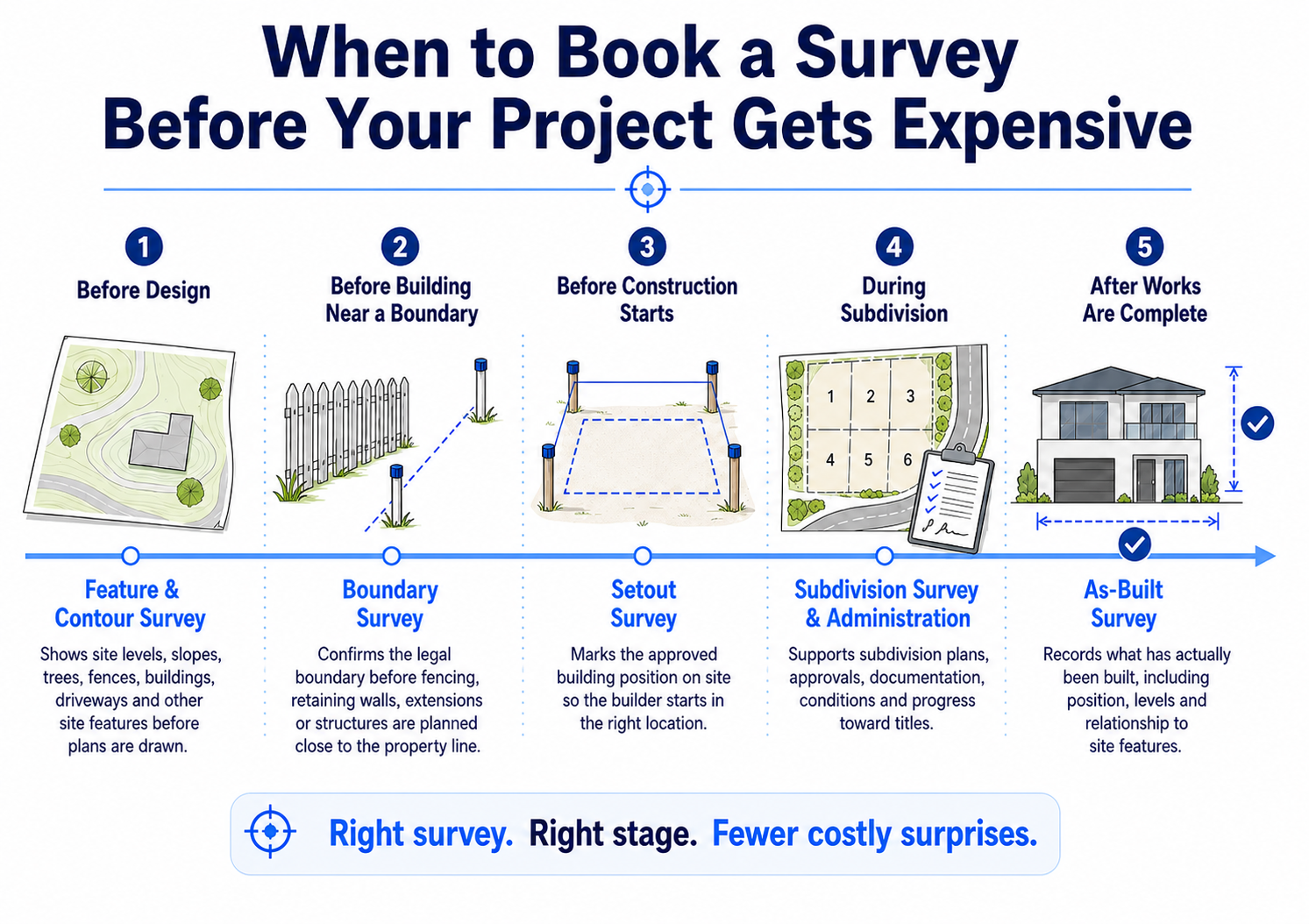
Common Types of Surveys in WA
Not every project needs the same survey.
A homeowner planning an extension may need one type of survey. A builder preparing a slab setout may need another. A developer looking at a subdivision will need a different level of detail again.
The purpose is simple: get the right information early, so design, approvals, construction and land development decisions are based on accurate site data rather than assumptions.
For Perth builders and developers, the right survey also helps keep scheduling, approvals, and site work moving.
Feature and Contour Survey
A feature and contour survey shows what is physically on the block before design, planning, or construction decisions are made.
It records details such as ground levels, slopes, trees, fences, walls, driveways, existing buildings, services, and other site features. It also shows the contours of the land, which helps designers understand how the block rises and falls. This gives architects, designers, engineers, and builders a reliable base plan to work from.
This survey is commonly used before:
- designing a new home
- planning an extension
- preparing development drawings
- lodging certain council or planning applications
- checking how the land may affect drainage, access, or building levels
Without this survey, designers and builders may be working from incomplete or assumed information. That can lead to redesigns, delays, or construction issues later.
Boundary Survey
A boundary survey helps identify the legal boundaries of a property using survey records and field measurements.
This matters because fences are not always built on the legal boundary. Over time, old fences, retaining walls, garden beds and neighbouring structures can make the true boundary harder to identify. This is especially important before construction, fencing, retaining wall work, or subdivision planning.
A boundary survey is often needed before:
- building close to a boundary
- replacing a fence or retaining wall
- buying or developing a property
- resolving a boundary concern
- planning a subdivision
- confirming how much land is actually available
For property owners, this survey can reduce uncertainty before decisions are made. For builders and designers, it provides a reliable boundary line to work from.

Construction Setout
A construction setout transfers the approved design from the plans onto the actual site.
The plans may show where a house, garage, wall, pool, or extension should go. The setout transfers that information from the drawings onto the land, so the builder can start in the right position.
This is one of the stages where survey accuracy matters most. For builders, a reliable setout helps reduce rework risk and keeps the job aligned with approved plans from the start. A small mistake at the beginning can become a large problem once concrete, brickwork, or structural work begins.
Construction setouts are commonly used for:
- new homes
- extensions
- garages and sheds
- retaining walls
- pools
- commercial or residential building works
A good setout helps builders start with confidence and keep construction aligned with the approved plans.
Subdivision Survey
A subdivision survey supports the process of dividing land into separate lots.
This may involve creating two lots from one block, developing a rear lot, preparing land for grouped dwellings, or working through a larger residential subdivision.
Subdivision surveying can include measuring the site, preparing survey plans, supporting title creation, and working with the information needed by planners, councils, and government authorities. Perth Surveying helps clients understand what survey information is needed, when it is needed, and how it fits into the broader subdivision pathway.
For property owners and small developers, this is where clear guidance matters. Subdivision is not just a line on a plan. It can involve access, services, zoning, lot sizes, easements, drainage, approvals, and titles.
If you are considering a subdivision in Perth or regional WA, Perth Surveying can help you understand the survey requirements, likely next steps and where the process may become more complex.
Subdivision Administration
Subdivision administration helps coordinate the survey, documentation and communication steps involved in moving a subdivision from approval towards titles. This may include coordinating documents, tracking conditions, communicating with relevant parties, and helping the process move from approval toward titles.
Many property owners underestimate how many steps are involved after they decide to subdivide. There may be applications, conditions, clearances, documents, authority requirements, and communication between different parties.
Subdivision administration helps keep those moving parts organised, reducing the chance that important steps are missed or delayed.
This is useful for property owners who want to unlock land value but do not know where to start, and for developers who want a clearer process from approval through to title.For developers, it also creates a clearer point of coordination across the survey and subdivision process.
Site Re-establishment Survey
A site re-establishment survey uses survey records and measurements taken in the field to identify the original boundaries of a property.
This is often used when boundary marks are missing, old, disturbed or unclear. It can also be important when a site is being prepared for construction or subdivision. Starting from the wrong boundary position can create costly issues later, especially when building close to a boundary or preparing subdivision plans.
It gives owners, builders, and consultants confidence that the project is starting from the correct legal position.
As-Constructed or As-Built Survey
An as-constructed survey, sometimes called an as-built survey, records what has actually been built on site.
Plans show what was intended. An as-built survey records what has actually been constructed, including its position, level and relationship to other site features.
This can be required for:
- drainage and services
- civil works
- retaining walls
- completed structures
- compliance checks
- project records
It is a practical way to confirm that completed works match the required position, level, or design intent. This gives owners, builders, engineers, and authorities a reliable record of completed work.
How Perth Surveying Helps
A good survey should do more than produce a plan. It should give the next stage of your project a clear, reliable starting point. Perth Surveying helps builders, developers, designers and property owners move forward with accurate site information, clear deliverables and timelines they can plan around.
We help property owners, builders, designers, and developers get reliable site information before they commit time and money to design, approvals, subdivision, or construction. Whether you are checking a boundary, preparing for a new build, planning a subdivision, or trying to understand what is possible on a block, the first step is knowing the land properly.
Perth Surveying helps by providing:
- Clear site information before decisions are made: We measure the land, levels, features, and boundaries so your architect, builder, planner, or engineer has reliable information to work from.
- Clear survey plans your project team can use: A survey should not create more questions than it answers. Our plans are prepared for clarity, helping builders, architects, engineers, planners, and owners understand the site faster.
- Reliable scheduling for builders and developers: Delays on site cost money. Perth Surveying focuses on confirmed scheduling, clear timeframes, and fast turnaround so projects can keep moving.
- Practical guidance for property owners: Subdividing or developing for the first time can feel complicated. We explain the next step in clear English, including what is required, why it matters, and what happens next.
- Local WA surveying knowledge: Perth property projects involve local site conditions, authority requirements, planning processes, and construction realities. A local WA team helps reduce uncertainty from the start.
- Support across the project journey: From early site surveys through to boundary work, construction setouts, subdivision surveys, and subdivision administration, Perth Surveying can support the key survey stages of a residential or development project.
We provide measured facts, clear communication, and reliable service that help move your project forward.
Tell us what you are planning, and we will help you understand the right next step.
Not sure whether you need a land surveyor, quantity surveyor, planner, engineer, or another property professional? Start by speaking with Perth Surveying. We can help you understand what kind of survey or advice your project needs next.
Need the right survey before your next design, build, boundary, or subdivision decision? Call Perth Surveying on 08 9303 2407, email admin@perthsurveying.com.au, or visit perthsurveying.com.au.
FAQs
Do I need a land surveyor or a quantity surveyor?
If your main concern is construction costs, budgets, or cost estimates, you may need a quantity surveyor. If you need to confirm boundaries, site levels, building position, site features, or subdivision requirements, you need a land surveyor. Many WA projects need accurate land information before reliable design, approval, or cost decisions can be made.
When should I book a survey for my property?
Book a survey before design, approvals, construction, fencing, retaining wall work, or subdivision decisions are made. Early surveying gives your builder, architect, planner, or engineer reliable site information from the start. It can help avoid redesigns, boundary issues, site delays, and expensive surprises later in the project.
Can Perth Surveying help with subdivision in WA?
Yes. Perth Surveying provides subdivision surveys and subdivision administration for property owners and developers in Western Australia. This may include site information, survey plans, boundary work, title survey requirements, and practical guidance so you understand what needs to happen next.
How early should I contact Perth Surveying?
Contact Perth Surveying as early as possible, especially before design, approvals, construction scheduling, or subdivision planning begins. Early survey information gives your project team accurate site data from the start and helps reduce delays later.
How much does a land survey cost in WA?
The cost depends on the survey type, site location, access, urgency and level of detail required. Perth Surveying can confirm the right survey and provide a quote based on your project.