Underground Scanning in Perth: What to Know Before You Dig

Underground Scanning in Perth: What to Know Before You Dig
Underground scanning helps builders, developers, contractors and property owners investigate where buried services may be located before excavation begins. It can reduce uncertainty around buried pipes, cables and other services, helping the project team plan safer work and avoid unnecessary disruption.
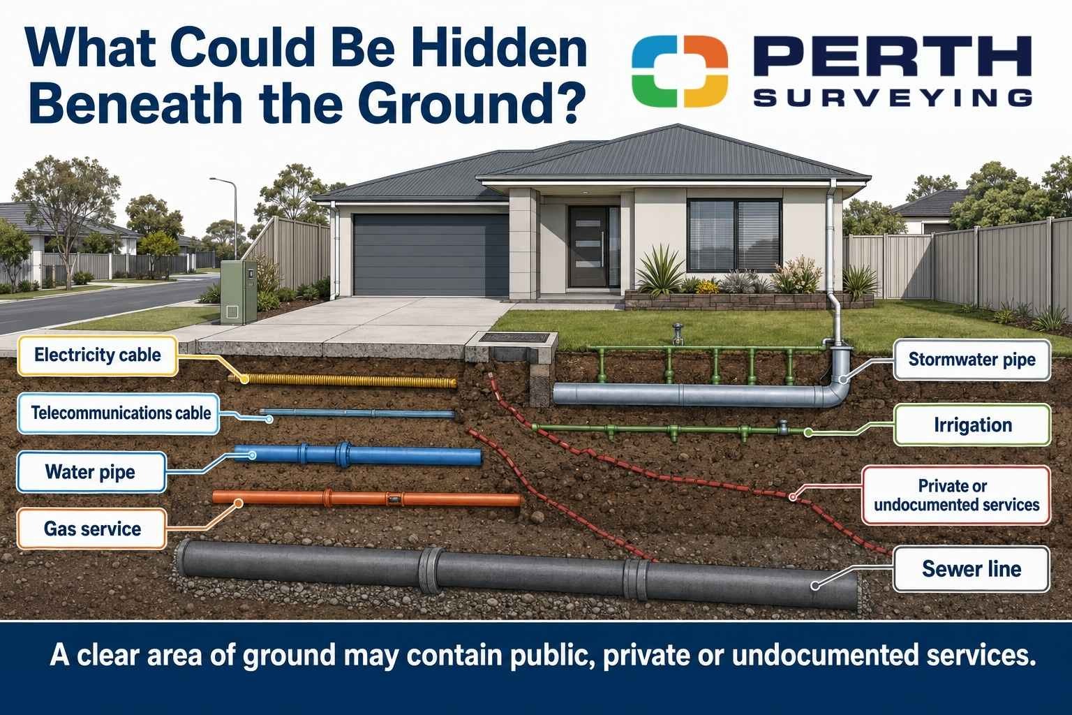
What appears to be a clear section of ground can contain electricity cables, telecommunications, water pipes, drainage, gas infrastructure or private services that are not obvious from the surface. Existing drawings may offer useful information, but they do not always show an asset’s exact position, depth or current condition.
For a builder preparing foundations, a pool contractor planning an excavation or a homeowner installing a new fence, an unexpected buried service can disrupt the entire job. Discovering a service after excavation has started leaves fewer options and can lead to delays, redesign or repair work.
A properly planned scan provides clearer information before machinery, drilling equipment or hand tools disturb the ground.
Why Underground Scanning Matters Before Excavation
Striking a buried service can result in much more than a damaged pipe.
Depending on the service involved, the consequences may include injury, electrical hazards, flooding, loss of communications, emergency repairs and disruption to nearby properties. The project may also stop while the service is assessed and repaired.
Underground service locating can help project teams identify and plan for risks such as:
- Damage to electrical or telecommunications cables
- Broken water, drainage or irrigation pipes
- Unexpected changes to footing or trench locations
- Delays while contractors wait for further information
- Additional excavation and reinstatement costs
- Disruption to construction sequencing
- Safety risks for workers and property occupants
- Rework caused by incomplete site information
In Western Australia, workplace managers must take reasonable steps to obtain current information about underground essential services before excavation begins and provide that information to the people carrying out the work. Underground scanning can form part of this wider planning and verification process.
What Is Underground Scanning?
Underground scanning is the process of investigating a defined area to identify indications of buried infrastructure or subsurface features.
The methods selected depend on the site, the type of services expected, and the information required. An underground scanning service may combine existing plans, a visual site inspection and specialised locating equipment.
Perth Surveying uses ground penetrating radar and electromagnetic locating equipment to support the detection and mapping of underground pipes, cables and other infrastructure.
Ground Penetrating Radar
Ground penetrating radar, commonly called GPR, sends radar energy into the ground and records reflections from subsurface materials.
Changes beneath the surface may appear as patterns in the collected data. An experienced operator interprets those patterns to identify possible services, structures, voids or other anomalies.
GPR is particularly useful when a service is non-conductive or cannot be traced using an electromagnetic signal. This may include some plastic, concrete or earthenware pipes.
The results can be affected by ground conditions, service depth, moisture, surface materials and interference. GPR, therefore, requires experienced interpretation; it is not simply a matter of moving equipment across the ground.
Electromagnetic Service Locating
Electromagnetic locating is commonly used to trace conductive pipes and cables.
A signal may be applied directly to a service, induced into it or detected from an existing current. A receiver is then used to follow the signal and mark the likely service alignment.
This method can be effective for metallic pipes, power and telecommunications cables, and services fitted with a trace wire. However, it may not locate every asset, particularly when the service is non-conductive, damaged, heavily congested or disconnected.
Using more than one method can provide a stronger understanding of a complex site.
Existing Plans and Service Records
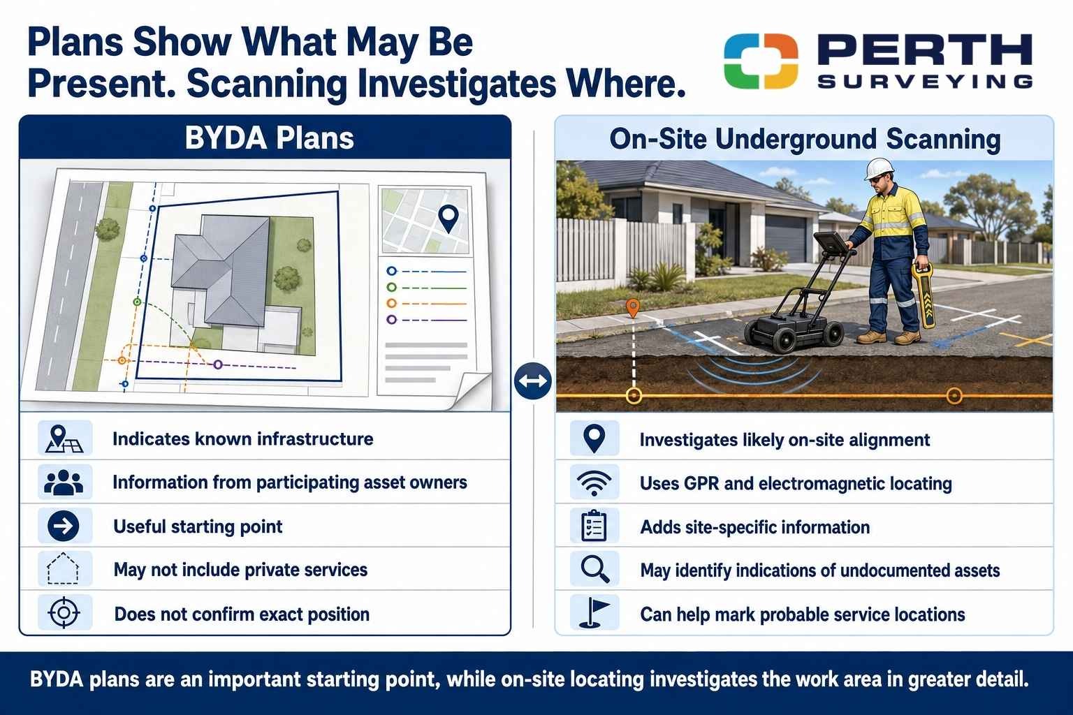
Before You Dig Australia provides a free process for requesting information from participating infrastructure owners. These plans are an important starting point for work near underground networks.
However, BYDA explains that supplied plans indicate the presence of infrastructure and should be treated as a guide rather than confirmation of an asset’s exact position.
Private services may also be missing from authority plans. Examples can include irrigation, private electrical connections, drainage installed during earlier renovations and services added after the original drawings were prepared.
Plans help identify what may be present. On-site locating helps investigate where it may actually be.
What Can Underground Scanning Detect?
The services that can be located depend on the site and the detection method.
Potential targets may include:
- Electrical cables
- Telecommunications cables
- Water pipes
- Gas services
- Sewer and drainage infrastructure
- Stormwater pipes
- Irrigation lines
- Fire services
- Private utility connections
- Redundant or undocumented services
- Underground tanks or structures
- Changes or anomalies beneath concrete and paving
A scan may identify the probable alignment of an asset without confirming exactly what the asset is. Further investigation may be required when identification, condition or precise depth is critical.
Physical exposure through approved potholing or non-destructive excavation may also be needed before high-risk excavation proceeds.
When Should Underground Scanning Be Arranged?
Scanning should be considered whenever work will break, penetrate or significantly load the ground.
Common projects include:
- New home construction
- Multi-unit residential developments
- Subdivision works
- Pool installation
- Granny flat construction
- Shed and workshop projects
- Retaining walls
- Fencing and gate installation
- Landscaping and tree planting
- Drainage upgrades
- Plumbing trenches
- Electrical upgrades
- Boring and drilling
- Road and civil works
- Commercial redevelopment
- Demolition and site clearing
Consider a residential builder preparing to set out a new home on an infill block. The site may have been occupied for decades and altered by previous owners. Old drainage, redundant power, private water lines or undocumented irrigation may remain underground.
Scanning the relevant work area before excavation gives the builder information that can be considered alongside the construction drawings and site plan.
The same principle applies to a homeowner installing a pool. A service crossing the proposed excavation may affect the pool position, the equipment layout or the project budget. Early information creates more room to make a practical decision.
How the Underground Scanning Process Works
A clear process improves both field efficiency and the usefulness of the final information.
Confirm the Proposed Work Area
The first step is understanding where excavation, drilling or construction will occur.
The field team may need the site address, a marked-up plan, the proposed footing layout, the trench route or another clearly defined area of interest. A broad instruction to scan the entire property may create unnecessary work when only one section will be disturbed.
Accurate project information helps match the scanning scope to the actual risk.
Review Plans and Available Records
Relevant BYDA plans, previous surveys, construction drawings and service records should be reviewed before fieldwork.
The documents may show likely service corridors, connection points and infrastructure owners. They can also highlight areas that require closer investigation.
Inspect and Scan the Site
The field operator inspects visible clues such as meters, pits, valves, access covers, conduits and changes in surface materials.
The selected scanning equipment is then used across the work area. Multiple passes or scan directions may be needed where the site is congested or the expected services are difficult to trace.
Mark and Record Findings
Detected service alignments may be marked on the ground so the project team can understand the likely position of buried infrastructure.
Depending on the agreed scope, the findings may also be captured in a plan, sketch, report or survey deliverable.
Explain Limitations and Next Steps
A useful result should identify any limitations that affected the investigation.
For example, access may have been restricted by stored materials, parked vehicles, permanent structures or active construction. Ground conditions may also reduce the quality of radar information.
Clear communication helps the builder, contractor, or owner understand what was investigated, what was indicated and whether further verification is recommended.
What Affects Underground Scanning Accuracy
No single scanning method can guarantee that every buried asset will be detected.
Detection quality can be influenced by:
- The type and material of the service
- The depth of the asset
- Ground moisture and soil composition
- Reinforcement within concrete
- Closely grouped services
- Electrical interference
- Restricted access
- Surface obstructions
- Incomplete service plans
- Redundant or disconnected infrastructure
- The operator’s experience
- The equipment and frequencies used
This does not make underground scanning unreliable. It means the service needs to be properly scoped and interpreted.
The best results come from combining good project information, suitable technology, experienced interpretation and clear reporting.
Underground Scanning and Land Surveying Are Different
Underground scanning and a conventional land survey answer different questions.
A feature and contour survey records visible site information such as levels, buildings, fences, trees, retaining walls and observable services. It gives designers and builders important information for planning and design.
Underground scanning investigates possible infrastructure beneath the surface.
A construction setout then positions proposed building work according to the approved drawings.
For some developments, these services can be coordinated as part of a broader project readiness process. A builder may need a feature and contour survey during design, underground service locating before excavation and a construction setout before the building work begins.
Coordinating the required work early can reduce repeated site visits, unclear instructions and last-minute scheduling pressure.
What Affects the Underground Scanning Cost
The cost of underground scanning depends on the scope and complexity of the work.
Important factors include:
- The size of the scanning area
- The number of separate work zones
- Expected service congestion
- The type of equipment required
- Site access and surface conditions
- Travel outside standard service areas
- Reporting and survey deliverables
- The urgency of the booking
- Whether additional survey support is required
A small residential work area with clear access will generally require less field time than a large civil site with several service corridors and complex reporting needs.
The best way to obtain an accurate quote is to provide the site address, proposed work area, project plans and required timeframe. This allows the service to be scoped properly before attendance.
Priority work may attract an additional charge when it requires changes to existing field schedules or accelerated reporting. Booking early gives the project team more scheduling options.
New clients are generally required to pay a deposit before site attendance, while approved builders and repeat commercial clients may receive structured account terms. Builders and approved repeat clients may be offered structured account terms.
How to Prepare the Site
Good preparation can improve field efficiency and reduce the chance of a return visit.
Before the booking:
- Provide plans showing the proposed excavation area
- Send available BYDA documents and service records
- Confirm the required deliverables
- Make sure gates and access points are available
- Move vehicles and stored materials away from the work area where practical.
- Secure pets
- Identify the site contact
- Advise the team about active construction hazards
- Mark the proposed work area clearly
- Explain when excavation is expected to begin
A clear work area gives the field team the best opportunity to collect useful information.
Choosing an Underground Scanning Provider
Price is one part of the decision, but it should not be the only factor.
Ask whether the provider:
- Uses both GPR and electromagnetic locating where appropriate
- Explains what is included in the scope
- Reviews available utility plans
- Provides clear site markings or deliverables
- Communicates limitations honestly
- Can coordinate surveying support when required
- Provides a confirmed booking process
- Understands Perth and Western Australian site conditions
- Responds clearly when the project team has questions
A low quote may provide poor value when the scope is unclear or the resulting information is not suitable for planning the work.
The goal is not simply to complete a scan. The goal is to give the project team clearer information before work starts.
Conclusion
Underground scanning is an important planning step for projects involving excavation, drilling, trenching or ground penetration.
It can help identify possible buried services, guide safer work planning and reduce the risk of disruption, rework and unexpected project delays. The most useful results come from combining service plans, visual site information, suitable detection methods and experienced interpretation.
Builders, developers, contractors and homeowners should arrange scanning early enough for the findings to influence the work. Waiting until the machinery is already on site leaves fewer options when a service is found.
Perth Surveying provides underground scanning and service locating across Perth Metro and broader Western Australia. The team focuses on clear scopes, reliable scheduling, practical communication and information that helps projects move forward.
Arrange Underground Scanning in Perth
Send Perth Surveying the site address, proposed work area, available plans and preferred timeframe. The team will confirm the scope, booking requirements and expected deliverables before attendance.
Call 08 9303 2407
Email sales@perthsurveying.com.au
Request an underground scanning quote at perthsurveying.com.au.
Clear deliverables. Clear timelines. Underground information that helps keep your project moving.
FAQs
Can underground scanning be completed through concrete?
GPR can often be used over concrete, paving and other finished surfaces, although the results depend on the slab, surface and target conditions. Results depend on factors such as slab reinforcement, thickness, access and the type of target being investigated.
The work area should be reviewed before attendance so the appropriate equipment and scanning approach can be selected.
Can I arrange scanning for only a small area?
Yes. A defined area around a proposed footing, pool, fence line, bore location, or trench can often be investigated.
Providing a marked-up plan or clear site markings helps ensure the field team scans the correct location.
How recent should a scan be before excavation?
Scanning should be completed close enough to the excavation date that the markings, site conditions and work area remain relevant.
A new assessment may be needed if the site changes, markings are removed, the excavation area moves, or additional services are installed after the original scan.
